Environmental Activism

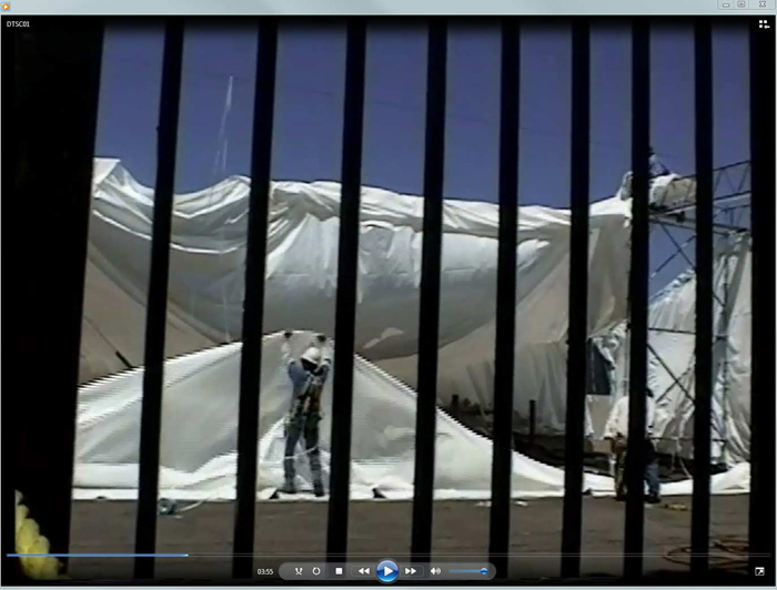
Within two weeks the wind tore the tent from many of its battens. The tent blew over the site, sending toxic dust onto and into the windows of the 45th Street Artists Cooperative across the street. The tent remained unsecured from the end of June through September, 1997.

About the Site
Information from the Agency for Toxic Substances & Disease Registry:
The Sherwin-Williams site in Emeryville, California is approximately 10 acres in size. Emeryville is located on the eastern side of the San Francisco Bay between Berkeley to the north, and Oakland to the east and south. The site is bounded by Horton Street to the east, Temescal Creek and the Rifkin Property to the north, railroad tracks to the west, and Sherwin Avenue to the south. The main facility, located on the Site at 1450 Sherwin Avenue, has been in operation since the early 1900's as a coatings manufacturer. In addition, the facility produced lead arsenate pesticides from the 1920's to the 1940's. It currently manufactures water-based paints and other coatings.
During the conversion of the plant in 1987 from the production of oil-based paints to water-based paints, contamination was discovered on site. In 1987, the paint manufacturing process was converted from oil-based products to water-based products. During this change, oil and solvent storage facilities were dismantled and Sherwin-Williams discovered groundwater and soil contamination. Several site investigations have determined that the primary contaminants on the site include volatile organic chemicals, semi-volatile organic chemicals, petroleum hydrocarbons, and metals (primarily arsenic and lead). Currently, the areas with contaminated soils have been covered with an asphalt cap, and the area with the most heavily contaminated groundwater has been enclosed with a slurry wall to reduce or prevent the migration of contaminated groundwater. A groundwater extraction and treatment system is operating with the goal of creating an inward hydraulic gradient across the slurry wall, thereby preventing arsenic and lead contaminated groundwater from migrating off site.
Various investigations at the Sherwin-Willliams facility, under oversight of the San Francisco Bay Regional Water Quality Control Board (RWQCB), have revealed contamination in the soil and groundwater of the Sherwin-Williams property by volatile organic chemicals, semi-volatile organic chemicals, petroleum hydrocarbons, and metals, primarily lead and arsenic. Contamination has also been found on other nearby properties. This includes volatile organic chemicals, total petroleum hydrocarbons, and arsenic contamination in the soil and shallow ground water of the southern Rifkin Property, and arsenic and lead contamination in the soils along both sides of Horton Street.
Directly across Horton Street from the Sherwin-Williams facility/site, at the corner of Horton and 45th Streets, is the 45th Street Artists' Cooperative (the Coop). The Coop facility was converted from a former industrial facility to live/work artist studios in 1974. Until about 1969, the Coop building was a part of a petrochemical research and development facility. The Coop consists of 32 studios, offices, and other facilities in a main facility (45th Street Building), and 24 additional studios in a second building (the Annex) located across the street to the south of the 45th Street building. Another housing development, the Horton Street Lofts, is also located to the south of the 45th Street Building, adjacent to the Coop Annex.
In the Spring of 1997, during construction activities on nearby properties, high levels of arsenic and lead were discovered in the soils on the site. This lead to an additional investigation which ultimately located high levels of arsenic and lead on the Coop property and in flower beds adjacent to the 45th Street Building and the Annex/Horton Street Lofts. Four general areas were identified and investigated: a Patio Area located on the northeast corner of the Coop property; a Garden Area located on the northwest corner of the Coop property and immediately across Horton Street from Sherwin-Williams; flower beds adjacent to the 45th Street building and directly across Horton Street from Shewin-Williams; and flower beds adjacent to the Annex/Horton Street Lofts on Horton Street and just down the street from Sherwin-Williams.
CDHS has concluded, assuming a worst-case scenario of daily exposure to the most contaminated soils for a period of greater than one year, that past levels of arsenic and lead on and near the Coop property posed a public health hazard for both non-cancer and cancer health effects. However, with the cleanup of the Garden Area on the Coop property and the flower beds along Horton Street adjacent to the 45th Street building and the Coop Annex/Horton Street Lofts, there is no longer a public health threat due to exposure to contaminants from these areas.
Additional Information
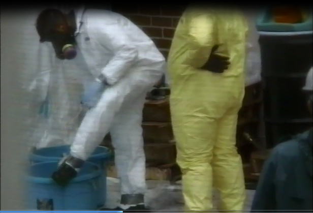
Residents in the neighborhood remained concerned about the levels of toxicity in the soil and with the cleanup gone awry, with levels of toxicity in the air. An ombudsman Mara Feeney was hired by Sherwin Williams to help mitigate the escalating frustration and anger on the part of the residents. Activism by the residents included attendance at meetings held by the site cleanup monitoring agency, the San Francisco Bay Regional Water Quality Control Board, the California Department of Toxics Substances Control, Sherwin Williams, and the agencies contracted by Sherwin Williams to undertake the cleanup. Other activities included research and the distribution of information regarding recent Environmental Protection Agency record fines against Sherwin Williams; unlicensed personnel sent by Sherwin Williams to collect hair samples from residents in the neighborhood; and other related information.
Arsenic and lead readings at 0.25 feet for Horton Street were as high as 180-320 ppm arsenic, 770-1600 ppm lead. (Identified as markers HS-45 and HS-46, "Figure 2 - concentrations of Inorganics Detected in Soil Samples Collected on the East Side of Horton Street, by Levine Fricke Recon). A "hot zone" further north on Horton Street had levels at 0.25 ft as high as 330-550 ppm arsenic and 'less than 1' to 2200 ppm lead (markers HS-28 and HS-27 in the document "Figure 2").
The "hot spot" within the hot zone:
Toxicologist Dr. Marilyn Underwood from California Health Services referred to an area within the hot zone, about 20 square feet, as having inexplicably high levels of arsenic and lead. At 1.0 feet levels measured were 86,000 ppm arsenic and 49,000 ppm lead. The hot spot was marked as HS-38 on the document referred to as "Figure 2".
A resident fronting the site submitted two dust-wipe samples from two interior windowsills on April 17, 1998 to Calcoast Analytical Laboratory in Emeryville for analysis. The Lab results, dated April 20, 1998: "Sample A contained 58,000 μg/ft2 lead. The US Department of Housing and Urban Development lists the Action Level for an interior windowsill at 500 μg/ft2 lead. Sample B contained 190 ug/ft2 arsenic."
Updates by the City of Emeryville
The most recent DTSC Fact Sheet describing the project and the soil transportation plan is found here, along with all the other technical documentation.
Sherwin Williams will finalize plans with the City of Emeryville in 2015 for a multi-structure live-work development on the site. Occupants of homes and offices surrounding the site are now organizing to influence the direction and oversight of this project.